Pinnacles National Park


Description
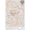
Tom Harrison maps have color-coded symbols and trails, mileages between trail junctions, latitude/longitude, UTM grids, contour lines, vegetation, and elevations at trail junctions.
- Published in 2018
- Scale 1:31,680
- 40 ft contours
